|
|
Crossing the Havasupai boundary to get to the South Bass Trail |
|
|
Crossing the Havasupai boundary to get to the South Bass Trail |
|
|
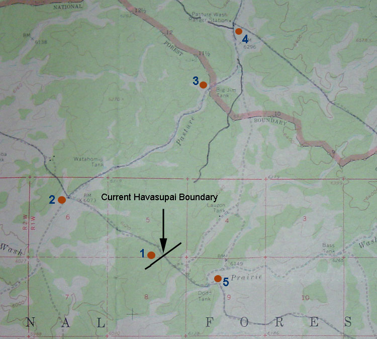 In the 1970s, the Havasupai Reservation was expanded to include land on
the plateau above the Grand Canyon. As a consequence, the road to
the South Bass trailhead, briefly, cuts through the reservation.
The road crosses into Havasupai lands at point 1 on the map, where there
is a fence and gate. I recall seeing only a grate there when I
first visited this area in the late 1970s/early 1980s. You turn at
the Pasture Wash junction (point 2) and cross back into
the National Park boundary at point 3 (after having been briefly back in
the national forest), continuing to the Bass trailhead
past the old Pasture Wash Ranger Station (point 4). This distance
is three to four miles.
In the 1970s, the Havasupai Reservation was expanded to include land on
the plateau above the Grand Canyon. As a consequence, the road to
the South Bass trailhead, briefly, cuts through the reservation.
The road crosses into Havasupai lands at point 1 on the map, where there
is a fence and gate. I recall seeing only a grate there when I
first visited this area in the late 1970s/early 1980s. You turn at
the Pasture Wash junction (point 2) and cross back into
the National Park boundary at point 3 (after having been briefly back in
the national forest), continuing to the Bass trailhead
past the old Pasture Wash Ranger Station (point 4). This distance
is three to four miles.
On a pleasant December day in 1995, I drove to the gate (point 1) and followed a rutted track north, along a fence line. When it ended, I walked to the park boundary and to the abandoned Pasture Wash Ranger Station (and, then, over to the rim above Pt. Huitzil). My route is highlighted on the map by the line that starts just above the word "Boundary." You can see a road that leaves from Dodd Tank (point 5) and crosses the park boundary near where I crossed on foot. I have tried to find, and follow, this road, but have been unsuccessful. A few years ago, I met someone with land interests in this area. He told me that the park service was planning on building a road to bypass the reservation, which would follow this old track from Dodd Tank. Alas, nothing has come of that proposal. Note that there is another road to Pasture Wash, shown right next to point 4. This is the park Boundary Road. I have driven along that road (from the Rowes Well area) on at least two occasions. The road was rough, but passable. And, slower than traveling along the National Forest roads. But, some years ago, officials at the park decided that this old road should be blocked off and the land designated as "wilderness." Although you can't tell from the map image above, most of this road is literally right next to the park boundary fence. From the road you can spit into the Kaibab National Forest. And, yet, this is wilderness? Completely insane. All this action did was to eliminate one possible route to South Bass that would bypass the Havasupais. Even if it was an inferior route, at least it was a choice. And, I can't imagine that more than a handful of hikers, like myself, ever used that road in any year. An irony, to be sure - because the road is so little used, there is no opposition to closing it down and ensuring that it never gets used.
If you have been to the South Bass trailhead in recent years, you will
have noted that the park service has actually done some improvements to
the parking. It is too bad that this effort is wasted because of
this more restrictive access. To my mind, the park service should
solve this problem, once and for all, by doing one of the following: If you feel that this situation should be addressed by the park, send a letter to the superintendent: Joseph
F. Alston, Superintendent Or, you can use their on-line form to send an e-mail. If you have comments you'd like to share on this, or other, Grand Canyon issues, feel free to write to me at the address below. |
|
|
|
|
