|
A couple of days after Thanksgiving, I did a day hike in the
Grand Canyon with hiking buddies John Eastwood and Bill Ferris. I decided to ask the editor of the Daily Sun if he'd be
interested in a story for his weekly Outdoors column, which runs each
Tuesday. He was enthusiastic and I penned something quite
quickly. He said it would run the next week (so, a bit less than
two weeks after Turkey Day). But, we got a big snowstorm that
weekend and he couldn't resist writing up some cross-country skiing
story. And, I got bumped the next week as well. Finally, the
story ran on Tuesday, December 20. Here is my version, which
is slightly different than the one he ran, but with his title:
|
Walking
off the holiday meal
Dennis Foster
It
is a couple of days after Thanksgiving and time to do some
serious work to counteract the effects of all that turkey,
stuffing, cranberry sauce, and, yes, the pumpkin pie.
Living in Flagstaff, there is no better way to do that than to
take a day hike in the Grand Canyon. Especially when the
weather is terrific – clear blue skies and balmy inner
canyon temperatures.
So, along
with two hiking buddies, we headed out of town at 7 a.m.
Our plan was to hike down the South Kaibab trail to the Tonto
trail, then over to Indian Garden and hike back up to the rim
on the Bright Angel trail. The total distance is about
13.5 miles and each trail segment – South Kaibab, Tonto and
Bright Angel – is about 4.5 miles.
The
temperature was right about freezing when we started down the
trail at nine o’clock. We were in the shade and it
stayed cold until we reached Cedar Ridge 1.5 miles down the
trail. The trail was busy with hikers but not crowded
like at other times of the year.
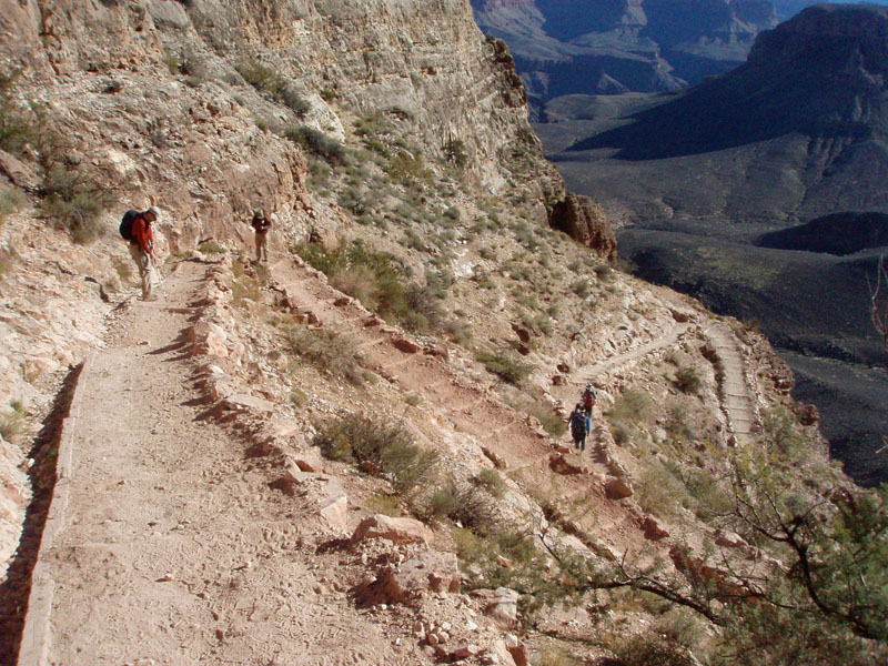
As we
continued down we got to see some of the work that has been
done on this trail over the last couple of years. The
improvement on the section through the Redwall is especially
noticeable, as the rocky stretches have now been replaced by
well formed steps.
At eleven
o’clock we reached the junction with the Tonto trail.
We headed west and began to contour our way through Pipe Creek
canyon. This trail gets a lot less use and is in a much
more primitive state. Not surprisingly, over the next
three hours, until we reached Indian Garden, we only saw two
other groups of hikers.
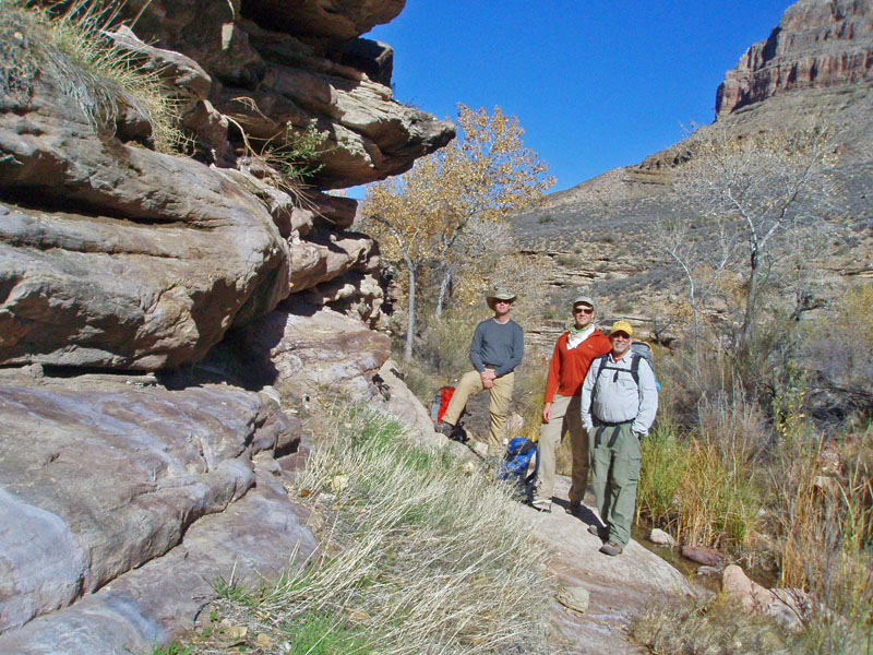
Pipe Creek
is perennial which makes it a great attraction at any time of
the year. We pulled in here a little after noon and ate
our lunch. The low lying winter sun quickly set behind
the South Rim above us, encouraging us to move on. From
here we hiked in the shade of the towering façade of the
South Rim nearly all the way to the Bright Angel trail.
Just
before reaching Indian Garden, the trail passes by the site
where Ralph Cameron once had some tent cabins for rent.
I brought along a copy of a photo of these tents that was
published in National Geographic in 1914. We found the
little terrace where these tents once stood, along with a few
pieces of metal.
At Indian
Garden there was construction going on at the restrooms along
the trail and the day use area was closed. So, we rested
in the campground area, snacking and filling up our water
containers. During the winter, the water faucets along
the trail above Indian Garden are turned off, so you need to
have all you’ll need when you leave here.
We started
out of Indian Garden at 2:30 p.m. and within fifteen minutes
were back into the shade, permanently. As we climbed up
the trail, it got colder and colder. By the time I
reached the rock with the ancient pictographs, about two miles
from the rim, I was back to wearing my fleece jacket and a
headband around my ears.
I was the
last of the group to reach the rim, topping out at just before
5:30 p.m., as the setting sun was casting a dim light that had
turned the very top of the north rim purple, signaling the end
of a perfect hiking day in the Grand Canyon. Perhaps a
reward is in order. I wonder if there is still pumpkin
pie at home?
Dennis
Foster lives in Flagstaff and has been an avid hiker in Grand
Canyon since 1977.
For
More Information:
Bright
Angel, Tonto and Hermit Trails: For information on
these, and other inner canyon trails, there are many trail
guides available. Among the most readily available is Scott
Thybony's "Official Guide to Hiking Grand Canyon."
You can find this at area bookstores, or online, at the Grand
Canyon Association website.
Backcountry Permits: Find information on permits and
trip planning at http://www.nps.gov/grca/index.htm
Grand
Canyon: To learn more about visiting the Grand Canyon go
to www.nps.gov/grca.
Or, you can find information at www.grandcanyonscout.com
| Click
on any picture (except granary closeup) to see a larger
image. |

I knew this was wrong! |

On the improved
Redwall stretch. |

Group photo
at Pipe Creek.
|

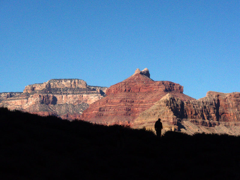
John silhouetted
against Isis Temple. |

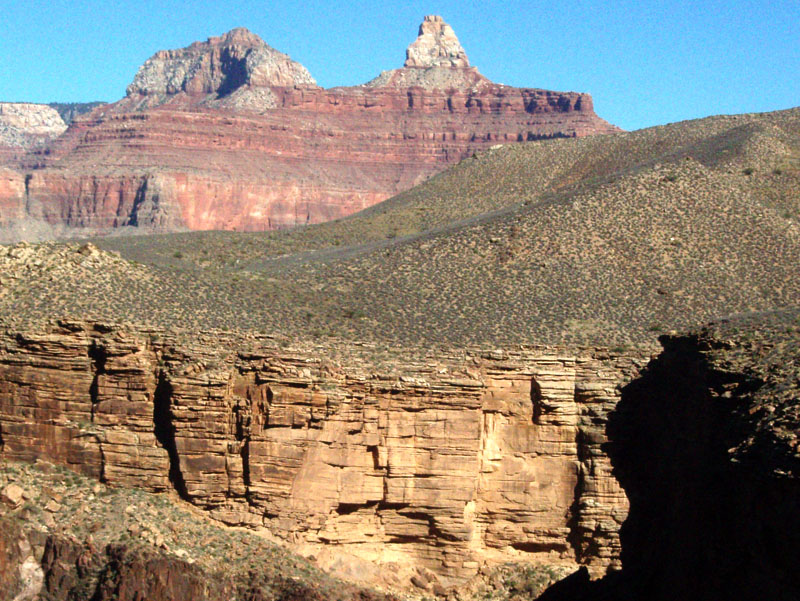
Zoroaster
looms over Pipe Creek ... |
... and the small granary within!
|
|
The paper ran two
photos - the group shot and the view of Indian Garden that appear
above. I have added a few others of interest. Some notes:
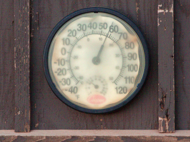
 The
thermometer at Cedar Ridge. The
photo shows that the "reading" was some 58 degrees.
Funny, since that is higher than the forecast high on the rim.
And, it was still early in the morning (9:30 am) and everyone was
bundled up. I'd say it was in the mid to upper 30s, making this
25 degrees too high. I have often noticed this during the
summer, when it will read 90 degrees plus, or even one hundred, when
it is clearly not that hot. So, this must be part of the Park
Service's deception plan to discourage hiking in the canyon!
Seems like the Department
of Justice has been trying to emulate them!
The
thermometer at Cedar Ridge. The
photo shows that the "reading" was some 58 degrees.
Funny, since that is higher than the forecast high on the rim.
And, it was still early in the morning (9:30 am) and everyone was
bundled up. I'd say it was in the mid to upper 30s, making this
25 degrees too high. I have often noticed this during the
summer, when it will read 90 degrees plus, or even one hundred, when
it is clearly not that hot. So, this must be part of the Park
Service's deception plan to discourage hiking in the canyon!
Seems like the Department
of Justice has been trying to emulate them!
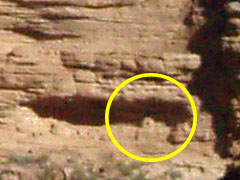
The
granary in Pipe Creek. The
photos above show the view looking back across Pipe Creek, with
Zoroaster (and Brahma) in the background. Quite impressive,
especially when you note that there is a tiny granary tucked away
under a ledge at the base of the Tapeats. The close up version
is a bit fuzzy, but you can see the dark hole in the middle where the
opening is. In the thumbnail of the bigger picture you can kind
of tell where it is, but if you click on it and get the full image,
you should be able to see the opening better. I have hiked by
this before, but it was back in the 1980s. I'll have to look up
those old photos some day!
Editor's
literary license. In
the published story, the editor inserted, "after taking the
shuttle bus to the trailhead," after my comment about starting
down the trail at 9 a.m. That wasn't true, but I can see his
interest in describing to the general public how to access the
trailhead. What really happened is that we parked at the nearby
picnic area and walked to the trailhead. That worked out for us
as John's wife, Kathy, came along but didn't want to do the whole
hike. She only went down to the top of the Redwall (which is
still 4-5 miles round trip) and then drove over to the Bright Angel
lodge, where she picked us up. Sweet deal for us, otherwise we'd
have had to budget in another hour, or so, for transit. Ugh!
More editorial
additions. In
the paper version, there are some additional comments from the editor
on the icy conditions of the upper couple of miles on these
trails. [Funny, that didn't make it into the web version, nor
did my "For More Information" section. Hmm...]
That was a key attraction to us - absolutely no snow or ice on these
trails for our hike even though it was right after Thanksgiving.
We did have some snow fall weeks earlier, but it was all gone for our
hike. I did, however, bring along my Kahtoola
micro spikes just in case!
The
Cameron tent cabins. I
mentioned these in my story on the backpacking trip from Indian Garden
to Hermit published almost exactly a year ago (Back
in the saddle). But, I didn't have room for photos. So, when we neared the Bright Angel trail, we matched up the old photo
I had copied out of the National Geographic Magazine from 1914 (that
the Kolbs had taken which was part of their long story in this issue) and scouted out the
site...

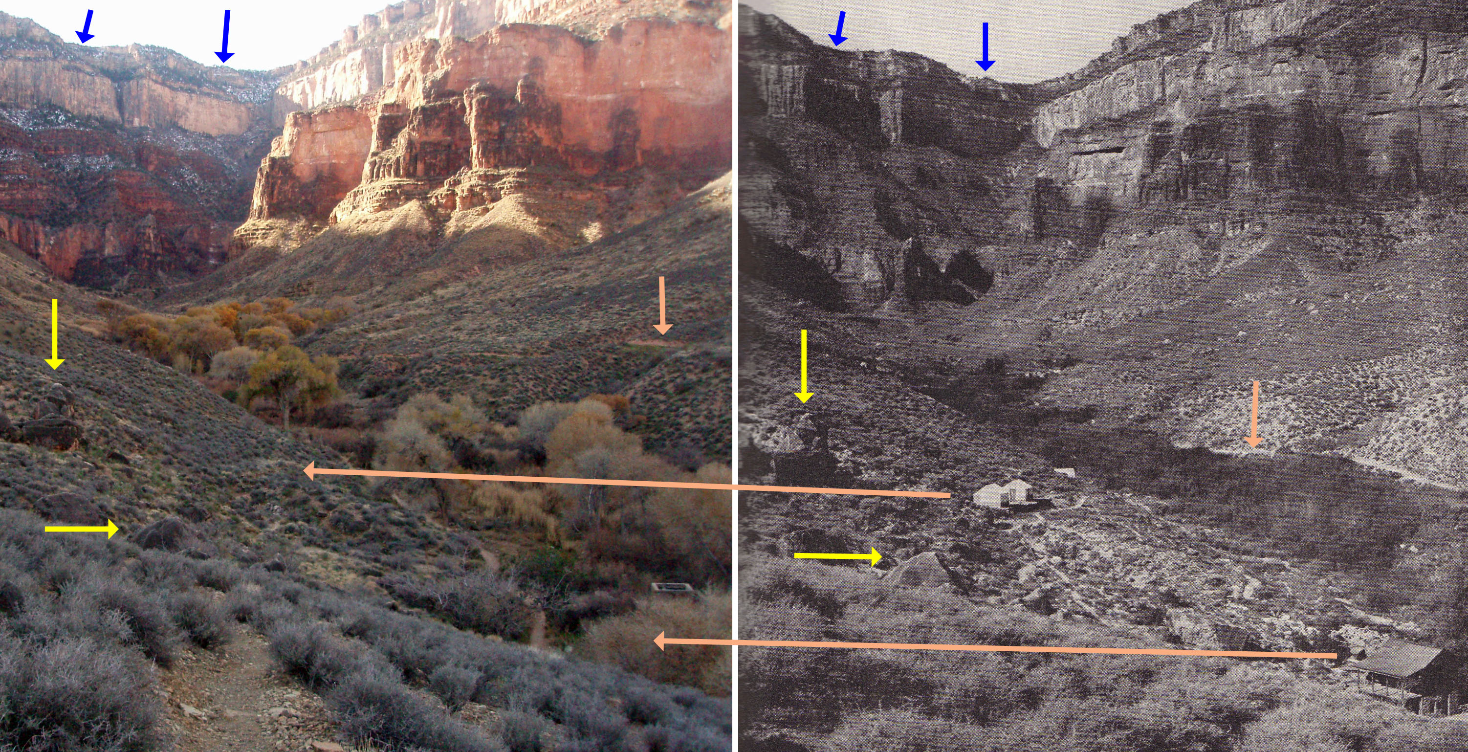
1/2012 update:
The photo I
used from this hike didn't really match up perfectly with the old Kolb
photo. So, on a later trip (BA
Wash ruins) I spent some time trying to better line up the
view. That is shown above, where I have indicated corresponding
physical features with the arrows (blue for the rim and yellow for the
big rocks). The short salmon arrows show where the Plateau Point
Trail is today versus back in the early 1900s. I've used the
other salmon arrows to show where Cameron's tent cabins would be
today, as well as where the Kolb's photo studio was located. I
have scouted around for any sign of the Kolb residence, but haven't
found anything. You can see another structure in the new photo,
which I believe is part of the old power plant. It could be that
the Kolb residence was completely removed with any usable material
going into the power plant buildings. [Click on the photo above
to see a bigger image.]
Another obvious change is that there are now lots of big trees in the
Garden Creek drainage. It used to be that this area flooded
rather often, which is why Cameron's facility was well up above the
bed. Indeed, if you wander around the campground here you
will notice a number of retaining walls whose purpose is to divert
water away from this area.
I
imagine that Indian Garden was a pretty hot place back in the
day! In fact, the tent cabin site now lies alongside the Tonto
trail. It used to be part of the old Bright Angel trail, which
went east out of Indian Garden and then followed a ravine down into
Pipe Creek. Along this old trail there are a few old Indian
ruins that I keep meaning to visit.
|

