 |
|
|
Pt.
Huitzil Notes by Dennis Foster
I had written up an extensive account of this hike well before the days of having my own web page. So, while I have just posted a short summary on my South Bass page, here is the full account. |
|
|
|
|
Pt.
Huitzil Notes by Dennis Foster
I had written up an extensive account of this hike well before the days of having my own web page. So, while I have just posted a short summary on my South Bass page, here is the full account. |
|
|
|
|
Pt.
Huitzil - Day Hike
John Eastwood and I went for a day hike to find the route
through the Coconino at Pt. Huitzil.
The weather continued very pleasant this winter.
It was clear and dry, with the temperature expected to reach 50. So, I wanted to do this trip while the roads were still
passable. In December,
1995, I was here for the same purpose, but had little time to scout out
the route as I had to walk through the forest just to get into the park.
I picked up John (in Cheshire area) at 6:35 am and we were at
the backcountry office at 8 am. I
wanted to pick up a spring break permit, and the office had just opened
on Saturday (following the federal gov’t. shutdown).
No one showed up at the office until about 8:20, and it wasn’t
the BRO person, but they issued permits to those of us standing around.
We then went to the ET, where John made some room reservations
for September. At 9:06 we
turned off of the West Rim Drive road and onto the road to the kennels. We reached the “trailhead” on the road west of the
Pasture Wash Ranger Station (PWRS) at 10:30 am.
This is where I had intended to drive to in December.
This time, the gate between the forest and the reservation was
open (although the sign is still on it).
By 10:49 we were on our way.
There is absolutely no snow around.
I took more careful note of the compass readings on our way to
the rim and they are recorded in the accompanying table.
We reached the bed of the ravine closer to the rim than when I
was here last. We were near
a junction of the main bed with a fainter bed, running to the south.
So faint that we passed it by on the way back.
We went through the Kaibab break and down to the top of the
Coconino. We contoured to
the left to a spot where we could look back at the area and try to
figure what the route was. I
had reread Harvey’s notes (which I brought along) and drew an
astounding conclusion--the route down through the Coconino is before
the Toroweap towers. That
is, to the south. Harvey
mentions about zigzagging up through the Coconino and once you get the
directions down it is clear that they went NW up to the wall at the base
of these towers. I had
thought that this next trip would investigate some possibilities further
along the Coconino, towards Pt. Huitzil.
We spent an hour and a half here looking, reading (and
munching). We had picked a spot in the sun, and there were no winds, but
it was still a bit chilly. John
spotted (I brought along my monocular) a constructed wall under an
overhang in the bay before the towers.
The wall supported a generally flat space here.
I concurred with his opinion about the rocks not being random and
that settled it--the route must be down this bay, just before reaching
the towers.
We spent some time trying to figure the route down, imagining
the switchbacking that would do the trick.
There were three or four major question marks along the way.
I drew a quick sketch of what seemed the most likely two
candidates. While we
didn’t use the sketch, the drawing of it did cement in my mind the
general lay of the land, so that it all seemed familiar when we got
there.
We easily reached the shelter with the wall.
There were six antlers there as well.
A reasonably worn route was visible in the slope, and we
encountered a few cairns. We,
then, were out on the sloping Coconino, heading down for a bit.
We reached a crack that was about seven feet high, with some
rocks jammed in at the bottom, which we used as a step to reach the next
level of Coconino. On this
level, a few feet away, is a big tree that was an important landmark we
could see from across the way. Twenty
feet along this sloping ledge one reaches a spot where there is a huge
detached block of the cliff. From
the opposite side of the bay, we wondered whether one could get down the
next 80 feet, or so, behind this block.
John checked it out and had chimneyed down it a bit before
returning.
I had waited at the top of the crack, along with our packs.
Beside me was a hole that had no apparent end, but would have
been quite a crawl on your belly to see where it went.
Further to my right was a rock cairn, near the obvious edge of
the cliff, which we both presumed marked the route down the crack where
we were. I handed down the
packs and joined John on this level.
Peering around to our right (north), John said that suitable
terrain was close, but we had a twelve foot cliff between it and us.
Looking back down the crack, I thought I detected some reflected
light coming from somewhere to the north.
John was about to climb back up the crack and check out the small
hole, but was game for trying the crack.
The end of the crack, where we were, was it’s narrowest and
John squeezed through, heel and toeing his way a bit above the floor for
a few feet, until he could reach, and shuffle along, the floor.
When he went around the bend there was much celebrating as he had
found Harvey’s hidden passage. The
crack was wider there and an old tree had been set, with steps cut into
it, leading up to Harvey’s “tunnel” which John came out of,
calling out “Guess where this is?”
It was the rock cairn that seemed mighty close to the edge of the
cliff. He recommended the
crack, given the somewhat precarious tree ladder.
In retrospect, I think the precarious position of this tunnel is
enough to make me prefer the crack!
At least, for going down. [But,
it is a tight fit!]
We came out at a level that continued along to the north for a
bit. I was a bit below John
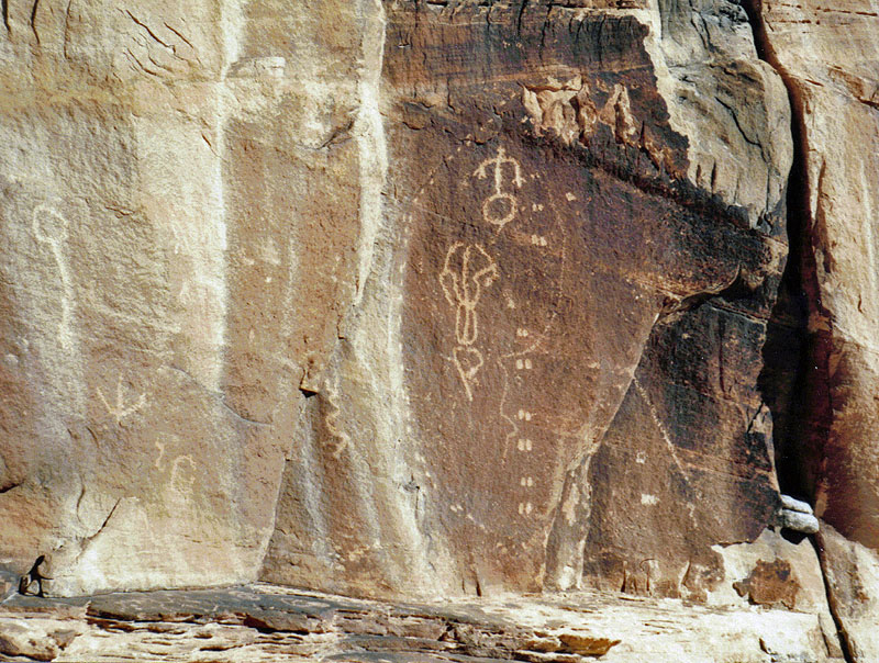
and turning to see him I saw three or four very distinct petroglyphs. I dropped by pack and grabbed my camera to get some photos.
As I got closer I saw more, and then, on the “floor” I
noticed dozens of them! What
a great area. We paused
briefly and then continued on. Soon
after passed the petroglyphs the route descends a bit and turns back to
the south (i.e., back towards the head of this canyon, which is not very
far away).
This bench slopes down and took us to the base of the big
detached block that John had started to chimney down.
We reached a spot where the rock was steeply sloped, and John
found the “moki steps” that Harvey mentions.
They don’t seem absolutely necessary, but we used them.
From here, the bench runs to the north, descending a bit, and
around a corner and down to the base of the Coconino.
This was not
the same place I had tried to come up last fall. This was some 20-30 yards further south, and really, the next
ridge leading down to the Supai. [An
additional point to distinguish this ridge--it is red near the Supai and
white near the base of the Coconino; the one I went up is the opposite,
white near the bottom and red at the top.]
So, my attempt up, and my later attempt down, were both in the
wrong spots. Now I don’t
feel so bad about having given up on them!
As it was already 3 pm, we stayed down only a few minutes and
then headed back up.
Going up, we stopped at the detached block and John climbed up
to the top, just to see if it could be done rather easily.
And, so it was. We
continued on and lunched in the petroglyph area and got to study them a
bit more. Then, we went up the tree ladder and out the tunnel.
At the top of the Coconino we looked for, but could not find, any
petroglyphs that Harvey also mentions.
We followed along the edge with the sheltered overhang, and there
are four of five of these “sites” here.
Topping out in the Toroweap, we went over to the towers and
decided to climb up here, rather than going back to the ravine and out.
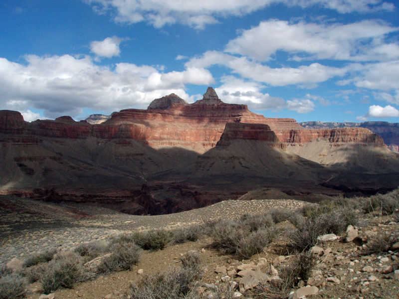
We went out to the end of Pt. Huitzil and had a great panoramic
view of the area.
Then, as it was now after 5 pm, it was a race back to the
truck, before it got dark. Well,
not exactly a race, but we were focused on the hike.
We had to climb a rather high ridge before reaching our proper
ravine, this route down isn’t especially easier than the way we came.
While hiking through the woods, once away from the ravine, we
tried to keep a southerly course. After
some ten minutes had past we were concerned, as we should have reached
the telephone line. I had
thought that we were dead on, with a bit of a correction to our left,
but something wasn’t right.
And, then, I saw the line.
I had kept an eye on the compass, held in my hand, and been alert
to possibly crossing the path, if we had somehow been past the point
where the line was down. Here,
the line was on the ground, and John had already walked right past it!
Well, so it goes! We
followed the line to the north, which seemed odd, until we reached its
end. About thirty feet away was the other end, where we had been,
now running east. So, we
had run into another section of the line, which corresponds to
Harvey’s comment about following the line until it turned south.
As we walked back along the line, we suddenly began to wonder
how we would know when to turn off for the truck.
We knew that we had to walk from the truck to the line, but could
not recall how far it was. I
had marked the time out, so we used that as a guide coming back.
It turned out not to be necessary, as the line passes within only
ten yards, or less, of the parking area. Hiking
Times
|
|
|
Return to Hiking Grand Canyon home page |